
Indiana facts for kids


Indiana is the Hoosier State (say in-dee-AN-uh), where Abraham Lincoln grew up. Its stone helped build the Empire State Building, and big sand dunes rise along its Lake Michigan shore.
Quick answers
- Where is Indiana?
- Indiana is in the Midwest region of the United States. It touches four states: Illinois, Kentucky, Michigan and Ohio.
- What is the capital of Indiana?
- Indianapolis. It’s also the biggest city.
- Does Indiana touch the ocean?
- No, but it has a shore on Lake Michigan, one of the Great Lakes.
- How big is Indiana?
- 36,420 square miles. It’s the 38th biggest of the 50 states.
Indiana at a glance
- Capital
- Indianapolis
- Nickname
- The Hoosier State
- Region
- Midwest in Map Otter. The US Census Bureau puts it in the Midwest.
- Became a state
- December 11, 1816, the 19th state
- Biggest city
- Indianapolis
- Size
- 36,420 square miles, the 38th biggest
- People
- About 7 million (2025), the 17th most
- Neighbors
- Illinois, Kentucky, Michigan and Ohio
Where is Indiana?
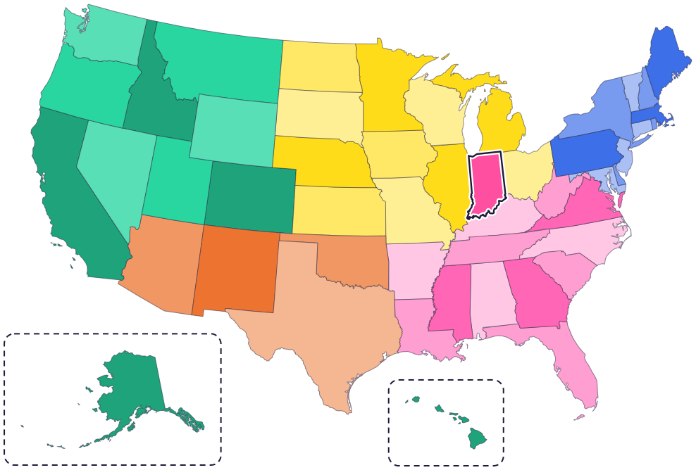
Indiana is in the Midwest. It touches four states: Michigan to the north, Ohio to the east, Kentucky to the south and Illinois to the west.
The Ohio River runs along the whole southern border, with Kentucky across the river. In the southwest, the Wabash River forms part of the border with Illinois. In the northwest corner, Indiana has 45 miles of Lake Michigan shore.
Fun facts
- 1
Indiana almost had no Lake Michigan shore. Congress moved its northern border 10 miles north so the state could reach the lake.
- 2
The name Indiana is “Indian” plus an “a” that means land. It was first used, around 1768, for land in what is now West Virginia.
- 3
Indiana limestone, the state stone, was used to build the Empire State Building and the Pentagon. It formed about 340 million years ago, when a shallow sea covered Indiana.
- 4
The state song, “On the Banks of the Wabash, Far Away,” is set beside the state river, the Wabash.
- 5
Cardinals, the state bird, stay in Indiana all year. Males are bright red. Females are brown, with dull red on the crest, wings and tail.
Places to know

Indiana Dunes National Park
Lake Michigan shore, northwest Indiana
It has 15 miles of Lake Michigan shore, with dunes, woods, prairies and wetlands. One big dune, Mount Baldy, is moving inland about 4 feet a year.

Lincoln Boyhood National Memorial
Lincoln City, southern Indiana
Abraham Lincoln lived on a farm here from age 7 to 21. You can visit a living history farm and the grave of his mother, Nancy Hanks Lincoln.
Falls of the Ohio State Park
Clarksville, on the Ohio River
Its fossil beds are about 390 million years old. More than 250 kinds of ancient corals have been found here.
Indiana long ago
People of the Mississippian culture build a town with 12 earth mounds beside the Ohio River, near today’s Evansville. Today it’s Angel Mounds State Historic Site.
Congress creates Indiana Territory. Its capital is Vincennes until 1813, when it moves to Corydon.
In June, 43 leaders meet in Corydon to write a constitution. On December 11, Indiana becomes the 19th state, with Corydon as its capital.
The state government moves from Corydon to the new capital, Indianapolis.
Many Myaamia (Miami) people, whose villages stood along the Wabash River, are forced to leave Indiana for Kansas. Today the Miami Tribe of Oklahoma’s home is in Oklahoma, and some of its citizens live in northern Indiana.
Indiana Dunes becomes the 61st national park.
State symbols
- State birdCardinalsince 1933
- State treeTulip treesince 1931
- State flowerPeonysince 1957
- State stoneLimestonesince 1971
- State riverWabash Riversince 1996
Tricks to remember Indiana
- Look under the mitten. Michigan’s Lower Peninsula is shaped like a mitten. Indiana sits under the left side of it, and Ohio under the right.
- Wiggly bottom, straight top. The Ohio River makes Indiana’s bottom edge wiggly. The top edge is a straight line, with a bit of Lake Michigan in the top-left corner.
- The capital has the state inside it. Indianapolis starts with “Indiana,” and it sits near the middle of the state.
- IN is for Indiana. The state’s two-letter postal code is IN, the first two letters of its name.
To practice, print a blank US map and color in Indiana, or find it in the 50 states quiz. Then try today’s mystery state: guess it from its shape, with a clue after each miss.
Teaching all 50? Read how to teach kids the 50 states and what age kids learn the states and capitals, or follow our free 36-week homeschool geography plan.
Indiana in Map Otter
In Map Otter, kids find Indiana on the map, learn its capital, and collect its stamp in their passport, with Otto guiding the way. These screenshots show how it looks with a few example states.



Map Otter is coming soon to iPhone, iPad, Android phones and tablets, and Chromebooks.
Questions kids ask
What is the capital of Indiana?
Indianapolis. The state government moved there in 1825 from Corydon, the first state capital.
What is a Hoosier?
A Hoosier is someone from Indiana. No one knows for sure where the word came from, but people were using it by the 1830s.
What is the biggest city in Indiana?
Indianapolis. It’s also the capital.
Did Abraham Lincoln live in Indiana?
Yes. He grew up on a farm in southern Indiana from age 7 to 21. Today it’s Lincoln Boyhood National Memorial.
Where these facts come from
- Indiana Historical Bureau: emblems and symbols
- Indiana Historical Bureau: state bird
- Indiana Historical Bureau: state tree and flower
- Indiana Historical Bureau: state river and stone
- Indiana Historical Bureau: state song
- Indiana Historical Bureau: the naming of Indiana
- Indiana Historical Bureau: what is a Hoosier?
- Indiana Historical Bureau: Indiana statehood timeline
- Indiana Historical Bureau: Constitution of 1851, Article 14 (boundaries)
- State of Indiana (America 250): statehood and Indiana’s borders
- Indiana DNR: Lake Michigan shoreline
- Indiana State Museum and Historic Sites: Corydon Capitol
- Miami Tribe of Oklahoma: about us
- National Park Service: Angel Mounds State Historic Site
- National Park Service: Indiana Dunes National Park
- National Park Service: Indiana Dunes history
- National Park Service: Mount Baldy
- National Park Service: Lincoln Boyhood National Memorial
- Indiana DNR: Falls of the Ohio State Park
- Indiana Department of Transportation: Indiana limestone
- US Census Bureau: state area measurements
- US Census Bureau: state population estimates, 2020 to 2025
- US Census Bureau: city and town population estimates, 2020 to 2025
- US Senate Manual: ratification of the Constitution by the 13 original states
- US Senate Manual: states admitted into the Union
- US Census Bureau: census regions and divisions
- NOAA Office for Coastal Management: shoreline mileage of the United States
