
Rhode Island facts for kids

Rhode Island, the Ocean State (say rohd EYE-luhnd), is the smallest state, but it has a big bay. Its state bird is a chicken, and its state drink is coffee milk.
Quick answers
- Where is Rhode Island?
- Rhode Island is in the Northeast region of the United States. It touches two states: Connecticut and Massachusetts.
- What is the capital of Rhode Island?
- Providence. It’s also the biggest city.
- Does Rhode Island touch the ocean?
- Yes. Rhode Island has a coast on the Atlantic Ocean.
- How big is Rhode Island?
- 1,545 square miles. It’s the smallest state.
Rhode Island at a glance
- Capital
- Providence
- Nickname
- The Ocean State
- Region
- Northeast in Map Otter. The US Census Bureau puts it in the Northeast.
- Became a state
- May 29, 1790, one of the 13 original states (the 13th to approve the Constitution)
- Biggest city
- Providence
- Size
- 1,545 square miles, the 50th biggest
- People
- About 1.1 million (2025), the 44th most
- Neighbors
- Connecticut and Massachusetts
Where is Rhode Island?
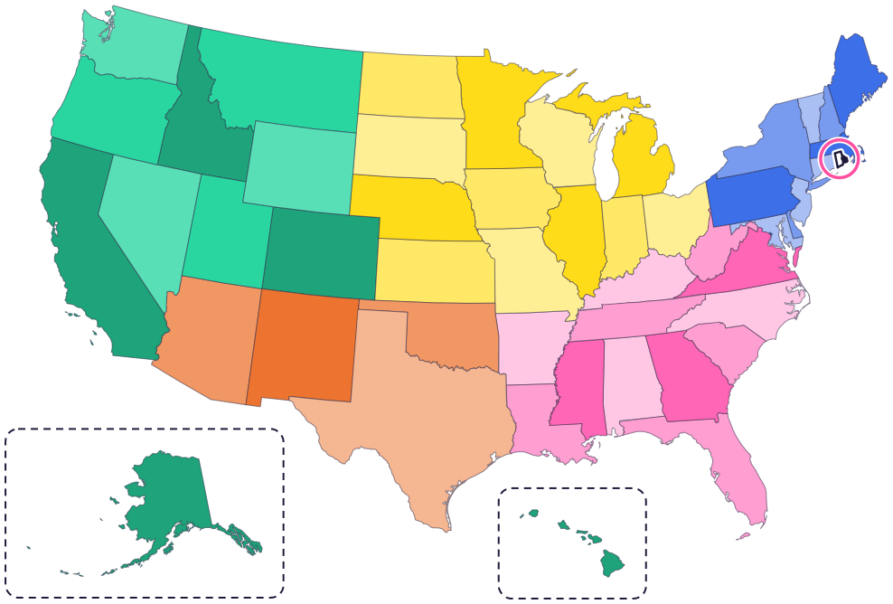
Rhode Island is in the Northeast, in the part of the country called New England. It touches two states: Connecticut to the west and Massachusetts to the north and east.
To the south is the Atlantic Ocean. Narragansett Bay reaches deep into the middle of the state, and Block Island sits out in the ocean to the south.
Fun facts
- 1
Rhode Island’s state bird is a chicken, the Rhode Island Red. These hens can lay up to 300 brown eggs a year.
- 2
The state drink is coffee milk. Mix it with vanilla ice cream and you get a Rhode Island “cabinet.”
- 3
Calamari, which is squid, is the state appetizer. Rhode Island has the largest squid-fishing fleet on the East Coast.
- 4
The state flag has a gold anchor, the word “Hope” and 13 gold stars in a circle.
- 5
Harbor seals, the state marine mammal, can grow to six feet long and weigh over 200 pounds.
Places to know

Slater Mill
Pawtucket
Built in 1793, it was the first successful water-powered cotton spinning mill in the United States. The Blackstone River powered its machines.
Touro Synagogue
Newport
It was dedicated in 1763 and still has an active congregation today. The National Park Service calls it the oldest synagogue in the United States.
Block Island National Wildlife Refuge
Block Island
To get to Block Island, you take a boat or a plane. The refuge is an important home for more than 70 kinds of songbirds that migrate.
Rhode Island long ago
Narragansett people live across much of what is now mainland Rhode Island. The Narragansett Indian Tribe says its people have been here for more than 30,000 years, and its home is still in Rhode Island today.
Roger Williams, forced out of the Massachusetts Bay Colony, founds Providence on land that Narragansett leaders gave him.
On May 29, Rhode Island approves the US Constitution, the last of the 13 original states to do so. The vote is close: 34 to 32.
Slater Mill is built in Pawtucket. Its water-powered machines spin cotton into thread.
Charles I. D. Looff designs and builds a carousel. Today it’s one of the few handmade carousels still in use, and the state symbol of American folk art.
Rhode Islanders vote to take “Providence Plantations” out of the state’s official name. Now it’s simply the State of Rhode Island.
State symbols
- State birdRhode Island Redsince 1954
- State drinkCoffee milksince 1993
- State shellQuahaugsince 1987
- State marine mammalHarbor sealsince 2016
- State treeRed maplesince 1964
Tricks to remember Rhode Island
- Look for the bite. Narragansett Bay cuts into the bottom of Rhode Island, almost splitting the state in two.
- Providence is at the top of the bay. Follow Narragansett Bay north as far as it goes, and you reach the capital.
- Hold on to Hope. The state flag has an anchor and the word “Hope,” the state motto.
- Small, with two neighbors. Connecticut is on the left, Massachusetts wraps around the top and the right side, and the ocean is below.
To practice, print a blank US map and color in Rhode Island, or find it in the 50 states quiz. Then try today’s mystery state: guess it from its shape, with a clue after each miss.
Teaching all 50? Read how to teach kids the 50 states and what age kids learn the states and capitals, or follow our free 36-week homeschool geography plan.
Rhode Island in Map Otter
In Map Otter, kids find Rhode Island on the map, learn its capital, and collect its stamp in their passport, with Otto guiding the way. These screenshots show how it looks with a few example states.



Map Otter is coming soon to iPhone, iPad, Android phones and tablets, and Chromebooks.
Questions kids ask
What is the capital of Rhode Island?
Providence, at the top of Narragansett Bay. Roger Williams founded it in 1636.
Is Rhode Island an island?
Not most of it. Most of the state is on the mainland, but it has islands too, in Narragansett Bay and out in the ocean, like Block Island.
What is the biggest city in Rhode Island?
Providence. It’s the capital, too.
What is Rhode Island’s nickname?
The Ocean State. It isn’t set by law, but the state uses it. Narragansett Bay reaches deep into the state, and the Atlantic Ocean is along its south side.
Where these facts come from
- Rhode Island Department of State: state symbols
- Rhode Island Department of State: facts and figures
- Narragansett Indian Tribe
- National Park Service: the Narragansett
- National Park Service: Roger Williams National Memorial
- National Park Service: Slater Mill
- National Park Service: Blackstone River Valley
- National Park Service: Touro Synagogue
- US Fish and Wildlife Service: Block Island National Wildlife Refuge
- US Senate Manual: ratification of the Constitution by the 13 original states
- US Census Bureau: state area measurements
- US Census Bureau: state population estimates, 2020 to 2025
- US Census Bureau: city and town population estimates, 2020 to 2025
- US Senate Manual: states admitted into the Union
- US Census Bureau: census regions and divisions
- NOAA Office for Coastal Management: shoreline mileage of the United States
