
Wisconsin facts for kids
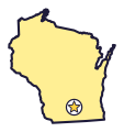

Wisconsin is the Badger State (say wis-KON-sin). It sits between two Great Lakes and has about 15,000 lakes of its own.
Quick answers
- Where is Wisconsin?
- Wisconsin is in the Midwest region of the United States. It touches four states: Illinois, Iowa, Michigan and Minnesota.
- What is the capital of Wisconsin?
- Madison. The biggest city is Milwaukee.
- Does Wisconsin touch the ocean?
- No, but it has a shore on Lake Superior and Lake Michigan, two of the five Great Lakes.
- How big is Wisconsin?
- 65,496 square miles. It’s the 23rd biggest of the 50 states.
Wisconsin at a glance
- Capital
- Madison
- Nickname
- The Badger State
- Region
- Midwest in Map Otter. The US Census Bureau puts it in the Midwest.
- Became a state
- May 29, 1848, the 30th state
- Biggest city
- Milwaukee
- Size
- 65,496 square miles, the 23rd biggest
- People
- About 6 million (2025), the 21st most
- Neighbors
- Iowa, Illinois, Michigan and Minnesota
Where is Wisconsin?
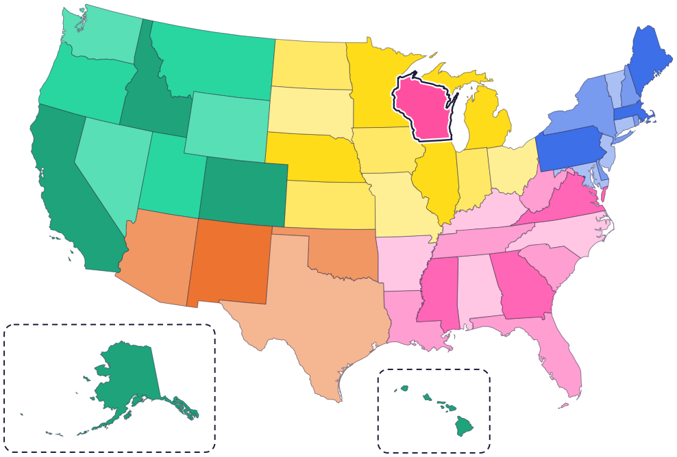
Wisconsin is in the Midwest, in the north-central part of the country. It touches four states: Minnesota to the west, Iowa to the southwest, Illinois to the south and Michigan to the northeast.
Lake Superior is to the north and Lake Michigan is to the east, with more of Michigan across the lake. The Mississippi and Saint Croix rivers form much of its western border.
Fun facts
- 1
Wisconsin has about 15,000 lakes.
- 2
The Apostle Islands, in Lake Superior, have more lighthouses than any other national park.
- 3
The Ice Age National Scenic Trail runs for 1,200 miles, past some of Wisconsin’s best landforms left by glaciers.
- 4
Lake Superior, along Wisconsin’s northern edge, hides shipwrecks under its waves.
- 5
The Ho-Chunk Nation’s traditional lands stretch across Wisconsin, Minnesota, Iowa, Missouri and Illinois.
Places to know
Apostle Islands National Lakeshore
Lake Superior, near Bayfield
It has 21 islands and a 12-mile shoreline on Lake Superior, with sea caves along the shore.
Devil’s Lake State Park
Near Baraboo
Cliffs of quartzite rock, 500 feet tall, look down on a 360-acre lake. The Ice Age Trail passes through the park.
Saint Croix National Scenic Riverway
Northwest Wisconsin and Minnesota
Two rivers, the Saint Croix and the Namekagon, make up this park, with over 200 miles of clean water winding through forests.
Wisconsin long ago
The Ho-Chunk say their history here goes back beyond possibly three ice ages. In their words, “we have always been here.”
Native Americans live on and around the Apostle Islands. The islands are an important place in Ojibwe culture today.
Wisconsin Territory is formed from land that had been part of Michigan.
On May 29, Wisconsin becomes a state.
A lighthouse on Michigan Island, one of the Apostle Islands, starts guiding ships on Lake Superior.
State symbols
- State animalBadgersince 1957
- State birdRobinsince 1949
- State flowerWood violetsince 1949
- State treeSugar maplesince 1949
Tricks to remember Wisconsin
- Two Great Lakes. Lake Superior touches the top of Wisconsin, and Lake Michigan runs down its right side.
- Look for the thumb. On the right side, a skinny piece of land called Door County pokes out into Lake Michigan, like a thumb.
- Madison sits between lakes. The capital is in the southern part of the state, on a strip of land between two lakes.
- River on the left. The Mississippi River runs along the lower part of the western edge.
To practice, print a blank US map and color in Wisconsin, or find it in the 50 states quiz. Then try today’s mystery state: guess it from its shape, with a clue after each miss.
Teaching all 50? Read how to teach kids the 50 states and what age kids learn the states and capitals, or follow our free 36-week homeschool geography plan.
Wisconsin in Map Otter
In Map Otter, kids find Wisconsin on the map, learn its capital, and collect its stamp in their passport, with Otto guiding the way. These screenshots show how it looks with a few example states.



Map Otter is coming soon to iPhone, iPad, Android phones and tablets, and Chromebooks.
Questions kids ask
What is the capital of Wisconsin?
Madison. It’s in the southern part of the state, between two lakes.
What is Wisconsin’s state animal?
The badger. It became the state animal in 1957, and Wisconsin is nicknamed the Badger State.
What is the biggest city in Wisconsin?
Milwaukee, on the shore of Lake Michigan.
How many lakes does Wisconsin have?
About 15,000.
Where these facts come from
- Wisconsin Statutes 1.10(3): state symbols
- Wisconsin Department of Natural Resources: lakes
- Wisconsin Department of Natural Resources: Devil’s Lake State Park
- National Park Service: Apostle Islands National Lakeshore
- National Park Service: Apostle Islands history and culture
- National Park Service: Apostle Islands lighthouses
- National Park Service: Ice Age National Scenic Trail
- National Park Service: Saint Croix National Scenic Riverway
- Ho-Chunk Nation: about
- US Senate Manual: states admitted into the Union
- Wisconsin Blue Book 2025–2026: state symbols
- US Census Bureau: state area measurements
- US Census Bureau: state population estimates, 2020 to 2025
- US Census Bureau: city and town population estimates, 2020 to 2025
- US Senate Manual: ratification of the Constitution by the 13 original states
- US Census Bureau: census regions and divisions
- NOAA Office for Coastal Management: shoreline mileage of the United States
