
Missouri facts for kids



Missouri, the Show-Me State (say muh-ZOOR-ee), has more than 7,500 caves. The Missouri River flows right across it, and its Gateway Arch is the tallest monument in the United States.
Quick answers
- Where is Missouri?
- Missouri is in the Midwest region of the United States. It touches eight states: Arkansas, Illinois, Iowa, Kansas, Kentucky, Nebraska, Oklahoma and Tennessee.
- What is the capital of Missouri?
- Jefferson City. The biggest city is Kansas City.
- Does Missouri touch the ocean?
- No. Missouri doesn’t touch an ocean or any of the Great Lakes.
- How big is Missouri?
- 69,707 square miles. It’s the 21st biggest of the 50 states.
Missouri at a glance
- Capital
- Jefferson City
- Nickname
- The Show-Me State
- Region
- Midwest in Map Otter. The US Census Bureau puts it in the Midwest.
- Became a state
- August 10, 1821, the 24th state
- Biggest city
- Kansas City
- Size
- 69,707 square miles, the 21st biggest
- People
- About 6.3 million (2025), the 18th most
- Neighbors
- Arkansas, Iowa, Illinois, Kansas, Kentucky, Nebraska, Oklahoma and Tennessee
Where is Missouri?
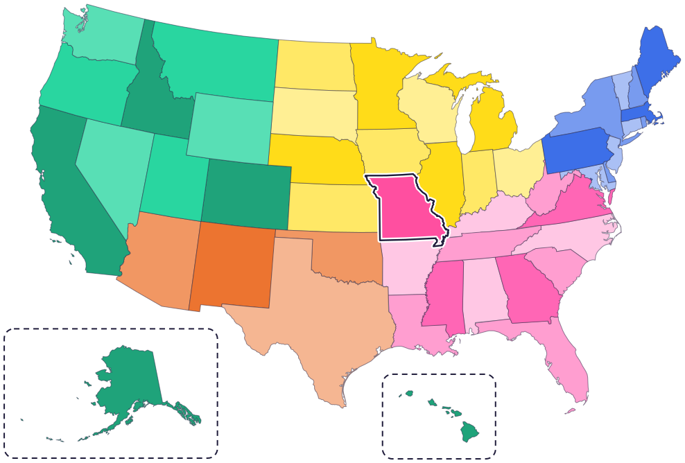
Missouri is in the Midwest, near the middle of the country. It touches eight states: Iowa to the north, Illinois, Kentucky and Tennessee to the east, Arkansas to the south, Oklahoma to the southwest, Kansas to the west and Nebraska to the northwest.
The Mississippi River runs along its whole eastern side. The Missouri River forms part of its western border, then flows east across the state and joins the Mississippi just north of Saint Louis.
Fun facts
- 1
More than 7,500 caves are known in Missouri, and it’s nicknamed the Cave State.
- 2
In winter, nearly 500,000 gray bats rest in just one Missouri cave. Gray bats are an endangered species.
- 3
Only one place in Missouri has ever turned up dinosaur bones. A family found the state dinosaur, a duck-billed dinosaur, there in 1942 while digging a well.
- 4
At the 1904 World’s Fair in Saint Louis, sellers shaped waffles into cones and filled them with ice cream. Today the ice cream cone is the state dessert.
- 5
In 1911, lightning struck the dome of the Capitol in Jefferson City, and the fire destroyed the building. The new Capitol has a statue of Ceres, the Roman goddess of farming, on its dome.
Places to know
Gateway Arch
Saint Louis
This shiny stainless steel arch is 630 feet tall, the tallest monument in the United States. A tram carries visitors up to the top.

Ozark National Scenic Riverways
Southern Missouri
It was the first national park area made to protect a river system. The Current and Jacks Fork rivers are great for floating, and the park has hundreds of springs and caves.

Harry S Truman National Historic Site
Independence
Tour the home of Harry S Truman, the 33rd president of the United States. He made Independence his hometown.
Missouri long ago
Osage people, who call themselves Wahzhazhe, settle along the Missouri and Osage rivers, in central and western Missouri. In the 1800s they were forced to leave. Today the Osage Nation’s home is in Oklahoma.
On May 21, Lewis, Clark and the Corps of Discovery set out from Saint Charles on their long trip west.
On August 10, President James Monroe signs a proclamation, and Missouri becomes the 24th state.
On October 1, the state government moves for good to Jefferson City. Until then, the capitol was in Saint Charles.
On April 3, the Pony Express makes its first run, from Saint Joseph to Sacramento, California. Riders carried mail more than 1,800 miles in about 10 days.
On October 28, workers finish the Gateway Arch in Saint Louis.
State symbols
- State animalMissouri mulesince 1995
- State birdEastern bluebirdsince 1927
- State flowerHawthorn blossomsince 1923
- State treeFlowering dogwoodsince 1955
- State fossilCrinoidsince 1989
Tricks to remember Missouri
- Count the stars. Missouri’s flag has 24 stars, because it was the 24th state.
- Find the Bootheel. A small piece sticks down at the bottom right corner, like the heel of a boot.
- Follow the Missouri. The Missouri River crosses the state, from Kansas City on the west side to just north of Saint Louis on the east side.
- Jefferson City is in the middle. The capital sits on the Missouri River, near the middle of the state.
To practice, print a blank US map and color in Missouri, or find it in the 50 states quiz. Then try today’s mystery state: guess it from its shape, with a clue after each miss.
Teaching all 50? Read how to teach kids the 50 states and what age kids learn the states and capitals, or follow our free 36-week homeschool geography plan.
Missouri in Map Otter
In Map Otter, kids find Missouri on the map, learn its capital, and collect its stamp in their passport, with Otto guiding the way. These screenshots show how it looks with a few example states.



Map Otter is coming soon to iPhone, iPad, Android phones and tablets, and Chromebooks.
Questions kids ask
What is the capital of Missouri?
Jefferson City. The state government moved there for good in 1826. Before that, the capitol was in Saint Charles.
Is the Show-Me State Missouri’s official nickname?
No. It isn’t one of Missouri’s official state symbols, but people use it a lot.
What is the biggest city in Missouri?
Kansas City, on the state’s western edge. Saint Louis is on the eastern edge.
How tall is the Gateway Arch?
630 feet. It’s the tallest monument in the United States, and you can ride a tram to the top.
Where these facts come from
- Missouri Secretary of State: state symbols
- Missouri Secretary of State: state animal
- Revised Statutes of Missouri 10.110: the Missouri mule
- Missouri Department of Conservation: Missouri’s state family
- Missouri Department of Conservation: Missouri caves
- Missouri Secretary of State: the state flag
- Missouri Secretary of State: state dinosaur
- Missouri Secretary of State: state dessert
- Missouri Secretary of State: state fossil
- Missouri Secretary of State: the State Capitol
- Missouri State Archives: timeline, 1673–1820
- Missouri State Archives: timeline, 1821–1860
- Missouri State Archives: timeline, 1950 to today
- Osage Nation: Osage cultural history
- Osage Nation: about the Osage Reservation
- National Park Service: Gateway Arch National Park
- National Park Service: the Gateway Arch at 50
- National Park Service: Ozark National Scenic Riverways
- National Park Service: Harry S Truman National Historic Site
- National Park Service: Pony Express National Historic Trail
- Missouri Secretary of State: state tree
- US Census Bureau: state area measurements
- US Census Bureau: state population estimates, 2020 to 2025
- US Census Bureau: city and town population estimates, 2020 to 2025
- US Senate Manual: ratification of the Constitution by the 13 original states
- US Senate Manual: states admitted into the Union
- US Census Bureau: census regions and divisions
- NOAA Office for Coastal Management: shoreline mileage of the United States
