
Massachusetts facts for kids


Massachusetts is the Bay State (say mas-uh-CHOO-sits), where the first battle of the American Revolution was fought. On a map, Cape Cod curls out into the ocean.
Quick answers
- Where is Massachusetts?
- Massachusetts is in the Northeast region of the United States. It touches five states: Connecticut, New Hampshire, New York, Rhode Island and Vermont.
- What is the capital of Massachusetts?
- Boston. It’s also the biggest city.
- Does Massachusetts touch the ocean?
- Yes. Massachusetts has a coast on the Atlantic Ocean.
- How big is Massachusetts?
- 10,554 square miles. It’s the 44th biggest of the 50 states.
Massachusetts at a glance
- Capital
- Boston
- Nickname
- The Bay State
- Region
- Northeast in Map Otter. The US Census Bureau puts it in the Northeast.
- Became a state
- February 6, 1788, one of the 13 original states (the 6th to approve the Constitution)
- Biggest city
- Boston
- Size
- 10,554 square miles, the 44th biggest
- People
- About 7.2 million (2025), the 16th most
- Neighbors
- Connecticut, New Hampshire, New York, Rhode Island and Vermont
Where is Massachusetts?
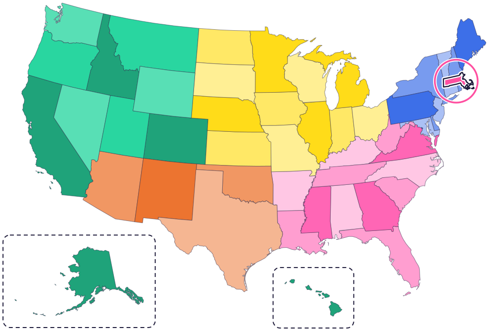
Massachusetts is in New England, in the northeast corner of the country. It touches five states: New Hampshire and Vermont to the north, New York to the west, and Connecticut and Rhode Island to the south.
To the east is the Atlantic Ocean. Cape Cod curls out into the ocean, and the islands of Martha’s Vineyard and Nantucket lie to its south.
Fun facts
- 1
Massachusetts takes its name from the Massachusett, a Native nation that is still here today. Massachusett people lived around the Great Blue Hill, south of Boston, and the name roughly means “at or about the Great Hill.”
- 2
The Boston terrier, the state dog, was the first purebred dog developed in America, back in 1869.
- 3
Deborah Samson, the official state heroine, fought in the Revolutionary War under a man’s name, Robert Shurtleff.
- 4
Boston Light, on an island in Boston Harbor, was first built in 1716. It’s the oldest light station in the country that has been in use the whole time, and it had the last official lighthouse keeper in the United States, until 2023.
- 5
Massachusetts has an official muffin, the corn muffin (1986), and an official donut, the Boston creme donut (2003).
Places to know
USS Constitution
Boston
Launched in Boston in 1797, it’s the oldest commissioned warship afloat in the world. It earned the nickname “Old Ironsides” in the War of 1812.
Minute Man National Historical Park
Concord
Walk the battlefields of April 19, 1775, the opening battle of the American Revolution, including Concord’s North Bridge.

Cape Cod National Seashore
Cape Cod
Forty miles of sandy beach, plus marshes, ponds, lighthouses and wild cranberry bogs.
Massachusetts long ago
Wampanoag people are living on this land, including Cape Cod and what is now Plymouth. Today the Mashpee Wampanoag Tribe’s home is in Mashpee, on Cape Cod, a town known as the Land of the Wampanoag.
The Pilgrims start a settlement at Plymouth, on Wampanoag land.
Boston Light, a lighthouse on an island in Boston Harbor, is built.
On April 19, the opening battle of the American Revolution is fought, including at Concord’s North Bridge.
On February 6, Massachusetts becomes the sixth state to approve the US Constitution.
The warship USS Constitution is launched in Boston. Boston is still its home today.
State symbols
- State birdBlack-capped chickadeesince 1941
- State dogBoston terriersince 1979
- State marine mammalRight whalesince 1980
- State dessertBoston cream piesince 1996
- State cookieChocolate chip cookiesince 1997
Tricks to remember Massachusetts
- Find the flexed arm. Cape Cod curls out into the Atlantic Ocean like an arm making a muscle.
- Double s, double t. Massachusetts has a double s near the start and a double t near the end: Massachusetts.
- Boston is on the bay. The capital, Boston, sits on the coast, on Massachusetts Bay.
- Two small states below. Connecticut and Rhode Island sit right under Massachusetts, like two blocks under a long shelf.
To practice, print a blank US map and color in Massachusetts, or find it in the 50 states quiz. Then try today’s mystery state: guess it from its shape, with a clue after each miss.
Teaching all 50? Read how to teach kids the 50 states and what age kids learn the states and capitals, or follow our free 36-week homeschool geography plan.
Massachusetts in Map Otter
In Map Otter, kids find Massachusetts on the map, learn its capital, and collect its stamp in their passport, with Otto guiding the way. These screenshots show how it looks with a few example states.



Map Otter is coming soon to iPhone, iPad, Android phones and tablets, and Chromebooks.
Questions kids ask
What is the capital of Massachusetts?
Boston. It’s also the state’s biggest city.
Who is Massachusetts named after?
The Massachusett, a Native nation. The tribe is still here today, and the name roughly means “at or about the Great Hill.”
What is Massachusetts’s nickname?
The Bay State. The state’s own fact book calls it the nickname most often used for Massachusetts.
Where did the American Revolution start?
The opening battle was fought in Massachusetts on April 19, 1775. You can walk the battlefields, including Concord’s North Bridge, at Minute Man National Historical Park.
Where these facts come from
- Massachusett Tribe at Ponkapoag
- Massachusett Tribe at Ponkapoag: we are the Massachusett
- Secretary of the Commonwealth: Massachusetts Facts (2019), State Library of Massachusetts
- National Park Service: Boston Light
- National Park Service: USS Constitution
- National Park Service: Minute Man National Historical Park
- National Park Service: Cape Cod National Seashore
- Mashpee Wampanoag Tribe: timeline
- Mashpee Wampanoag Tribe: museum
- US Senate Manual: ratification of the Constitution by the 13 original states
- US Census Bureau: state area measurements
- US Census Bureau: state population estimates, 2020 to 2025
- US Census Bureau: city and town population estimates, 2020 to 2025
- US Senate Manual: states admitted into the Union
- US Census Bureau: census regions and divisions
- NOAA Office for Coastal Management: shoreline mileage of the United States
