
Maryland facts for kids

Maryland is the Old Line State (say MAIR-uh-luhnd), and it wraps around the Chesapeake Bay. Its state sport is jousting. Its state dinosaur has a star pattern inside its teeth.
Quick answers
- Where is Maryland?
- Maryland is in the Northeast region of the United States. It touches four states: Delaware, Pennsylvania, Virginia and West Virginia, and it borders Washington, D.C.
- What is the capital of Maryland?
- Annapolis. The biggest city is Baltimore.
- Does Maryland touch the ocean?
- Yes. Maryland has a coast on the Atlantic Ocean.
- How big is Maryland?
- 12,406 square miles. It’s the 42nd biggest of the 50 states.
Maryland at a glance
- Capital
- Annapolis
- Nickname
- The Old Line State
- Region
- Northeast in Map Otter. The US Census Bureau puts it in the South.
- Became a state
- April 28, 1788, one of the 13 original states (the 7th to approve the Constitution)
- Biggest city
- Baltimore
- Size
- 12,406 square miles, the 42nd biggest
- People
- About 6.3 million (2025), the 19th most
- Neighbors
- Washington, D.C., Delaware, Pennsylvania, Virginia and West Virginia
Where is Maryland?
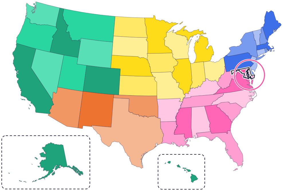
Maryland is on the East Coast. It touches four states and Washington, D.C.: Pennsylvania to the north, Delaware to the east, Virginia to the south, and West Virginia to the south and west. Washington, D.C., sits on its southwestern edge.
The Chesapeake Bay cuts deep into the state, and the Potomac River forms much of its southern border. On the Eastern Shore, a short stretch of beach faces the Atlantic Ocean.
Fun facts
- 1
Maryland was the first state to pick an official sport: jousting, in 1962. Riders gallop down a course and try to spear small hanging rings with a long lance.
- 2
The state dinosaur, Astrodon johnstoni, has a name that means “star tooth.” A scientist sliced one of its teeth and found a star pattern inside.
- 3
The Chesapeake Bay is the largest estuary in the nation, a place where rivers meet the sea. Fresh water flows into it from 150 major rivers.
- 4
The blue crab’s scientific name, Callinectes sapidus, is said to mean “beautiful swimmer that is savory.” In Crisfield, crabs even run races every Labor Day weekend.
- 5
In 1830, a steam engine called Tom Thumb raced a train pulled by a horse in Baltimore.
Places to know
Fort McHenry
Baltimore
In 1814, the fort’s brave defense during the Battle of Baltimore inspired Francis Scott Key to write the words of the national anthem. Visitors can help rangers raise the flag.
Assateague Island National Seashore
Eastern Shore
Wild horses roam this island. They probably come from horses brought here in the late 1600s. Give them plenty of space, and never feed or pet them.

Maryland State House
Annapolis
The oldest state capitol still used by lawmakers without a break, and the only state house that ever served as the nation’s capitol.
Maryland long ago
Many Native bands and tribes live in what is now Maryland. Their people are still here: Maryland formally recognized the Piscataway tribes in 2012 and the Accohannock Tribe in 2017.
On March 25, English settlers from the ships Ark and Dove land at Saint Clement’s Island. Two days later they start Saint Mary’s City, Maryland’s first capital.
The capital moves to Anne Arundel Town, which is renamed Annapolis.
George Washington resigns as head of the Continental Army at the State House in Annapolis. Until 1784, Annapolis is the capital of the new nation.
On April 28, Maryland becomes the seventh state to approve the US Constitution.
British ships bomb Fort McHenry for 25 hours. The American flag still flying afterward inspires Francis Scott Key to write the poem that becomes “The Star-Spangled Banner.”
State symbols
- State crustaceanBlue crabsince 1989
- State birdBaltimore oriolesince 1947
- State flowerBlack-eyed Susansince 1918
- State dogChesapeake Bay retrieversince 1964
- State sportJoustingsince 1962
Tricks to remember Maryland
- Mary’s land. Maryland is named for a queen, Henrietta Maria. Think “Mary’s land.”
- Find the bay. The Chesapeake Bay almost cuts Maryland in two. The land east of the bay is called the Eastern Shore.
- A skinny arm to the west. Western Maryland is a thin strip squeezed between Pennsylvania and West Virginia.
- Annapolis sits by the bay. The capital is on the Chesapeake Bay’s western side, south of Baltimore and east of Washington, D.C.
To practice, print a blank US map and color in Maryland, or find it in the 50 states quiz. Then try today’s mystery state: guess it from its shape, with a clue after each miss.
Teaching all 50? Read how to teach kids the 50 states and what age kids learn the states and capitals, or follow our free 36-week homeschool geography plan.
Maryland in Map Otter
In Map Otter, kids find Maryland on the map, learn its capital, and collect its stamp in their passport, with Otto guiding the way. These screenshots show how it looks with a few example states.



Map Otter is coming soon to iPhone, iPad, Android phones and tablets, and Chromebooks.
Questions kids ask
What is the capital of Maryland?
Annapolis. It has been the capital since 1695, and in 1783 and 1784 it was the capital of the whole country.
Who is Maryland named after?
Queen Henrietta Maria, the wife of King Charles I of England. He signed the 1632 charter that started the Maryland colony.
Why is Maryland called the Old Line State?
Some historians say George Washington gave it that name, for Maryland’s “line” troops who fought in many Revolutionary War battles. It’s also called the Free State, a name first used in 1864, when Maryland’s new constitution ended slavery.
What is the biggest city in Maryland?
Baltimore, about 25 miles north of Annapolis.
Where these facts come from
- Maryland State Archives: state sport and team sport
- Maryland State Archives: state dinosaur
- Maryland State Archives: state crustacean
- Maryland State Archives: Chesapeake Bay
- Maryland State Archives: historical chronology, 1800–1899
- Maryland State Archives: historical chronology, 1600–1699
- Maryland State Archives: historical chronology, 1700–1799
- Maryland State Archives: Indigenous peoples
- Maryland State Archives: the name Maryland
- Maryland State Archives: Maryland’s nicknames
- Maryland State Archives: state bird
- Maryland State Archives: state flower
- Maryland State Archives: state dog
- Maryland State Archives: the Maryland State House
- National Park Service: Fort McHenry
- National Park Service: Assateague’s wild horses
- Maryland State Archives: Annapolis, the capital
- US Census Bureau: state area measurements
- US Census Bureau: state population estimates, 2020 to 2025
- US Census Bureau: city and town population estimates, 2020 to 2025
- US Senate Manual: ratification of the Constitution by the 13 original states
- US Senate Manual: states admitted into the Union
- US Census Bureau: census regions and divisions
- NOAA Office for Coastal Management: shoreline mileage of the United States
