
North Dakota facts for kids
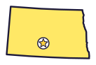
North Dakota is the Peace Garden State (say north duh-KOH-tuh), named for a big garden it shares with Canada on the border. Theodore Roosevelt once hunted bison in its badlands.
Quick answers
- Where is North Dakota?
- North Dakota is in the Midwest region of the United States. It touches three states: Minnesota, Montana and South Dakota.
- What is the capital of North Dakota?
- Bismarck. The biggest city is Fargo.
- Does North Dakota touch the ocean?
- No. North Dakota doesn’t touch an ocean or any of the Great Lakes.
- How big is North Dakota?
- 70,698 square miles. It’s the 19th biggest of the 50 states.
North Dakota at a glance
- Capital
- Bismarck
- Nickname
- The Peace Garden State
- Region
- Midwest in Map Otter. The US Census Bureau puts it in the Midwest.
- Became a state
- November 2, 1889, the 39th state
- Biggest city
- Fargo
- Size
- 70,698 square miles, the 19th biggest
- People
- About 800,000 (2025), the 47th most
- Neighbors
- Minnesota, Montana and South Dakota
Where is North Dakota?
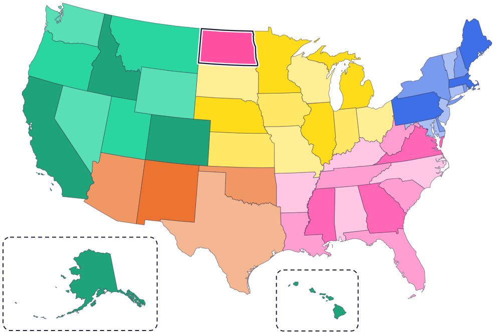
North Dakota is in the Midwest, in the north-central part of the country. It touches three states: Minnesota to the east, South Dakota to the south and Montana to the west.
To the north is Canada, with the provinces of Saskatchewan and Manitoba. The Red River of the North forms most of its border with Minnesota, and the Missouri River flows through the western half of the state.
Fun facts
- 1
The state is named for the Dakota people. In the Dakota language, the word Dakota means “friend” or “ally.”
- 2
Nobody knows whether North Dakota or South Dakota became a state first. They became states on the same day.
- 3
Lawmakers have twice said no to dropping “North” from the state’s name, in 1947 and again in 1989.
- 4
Another nickname is the Flickertail State, after Richardson ground squirrels that flick their tails. Lots of them live in North Dakota.
- 5
The state record northern pike weighed about 37 and a half pounds. It was caught in Lake Sakakawea in 1968.
Places to know
Theodore Roosevelt National Park
Western North Dakota
Theodore Roosevelt first came to these colorful badlands in 1883 to hunt bison. Bison still roam here, and in the fall you can hear bull elk bugle.

Knife River Indian Villages
Near Stanton
For hundreds of years, this was a big Native American trade center. Hidatsa and Mandan people lived in earthlodge villages here. They farmed and hunted bison.

International Peace Garden
On the border with Manitoba, Canada
Founded in 1932, it sits right on the border between the United States and Canada. It has nearly 2,400 acres of gardens and trails, and even a floral clock.
North Dakota long ago
Hidatsa and Mandan people live in earthlodge villages along the Knife River, a busy trade center. Today the Mandan, Hidatsa and Arikara Nation’s home is the Fort Berthold Reservation, on the Missouri River in North Dakota.
Lewis and Clark build Fort Mandan and stay for the winter. Sakakawea (also spelled Sacagawea) and Charbonneau join the expedition there.
Dakota Territory is created. At first it includes today’s North and South Dakota, plus Montana and Wyoming.
Theodore Roosevelt comes to the Dakota badlands to hunt bison.
On November 2, North Dakota and South Dakota both become states.
The International Peace Garden is founded on the border with Canada.
State symbols
- Honorary equineNokota horsesince 1993
- State birdWestern meadowlarksince 1947
- State flowerWild prairie rosesince 1907
- State fossilTeredo-bored petrified woodsince 1967
- State fishNorthern pikesince 1969
Tricks to remember North Dakota
- North sits on top of South. North Dakota is right above South Dakota, just like the names say.
- A rectangle with a wiggly side. North Dakota is almost a rectangle. Its right side wiggles because it follows the Red River.
- Bismarck is on the Missouri. The capital sits on the Missouri River, in the south-central part of the state.
- Peace at the top. The International Peace Garden sits on the border with Canada, near the middle of the top edge.
To practice, print a blank US map and color in North Dakota, or find it in the 50 states quiz. Then try today’s mystery state: guess it from its shape, with a clue after each miss.
Teaching all 50? Read how to teach kids the 50 states and what age kids learn the states and capitals, or follow our free 36-week homeschool geography plan.
North Dakota in Map Otter
In Map Otter, kids find North Dakota on the map, learn its capital, and collect its stamp in their passport, with Otto guiding the way. These screenshots show how it looks with a few example states.



Map Otter is coming soon to iPhone, iPad, Android phones and tablets, and Chromebooks.
Questions kids ask
What is the capital of North Dakota?
Bismarck. It’s on the Missouri River, in the south-central part of the state.
Why is it called the Peace Garden State?
For the International Peace Garden on the border with Canada. The name went on license plates in 1956 and became official in 1957.
Which Dakota became a state first?
Nobody knows. Both became states on November 2, 1889, and the exact order is unknown. North Dakota is often called the 39th state because it comes first in the alphabet.
What is the biggest city in North Dakota?
Fargo, on the Red River at the state’s eastern edge.
Where these facts come from
- North Dakota state government: nicknames
- North Dakota state government: fun facts and the origin of the name
- North Dakota Studies (State Historical Society): the Nokota horse
- North Dakota Century Code, chapter 54-02: state emblems and symbols
- North Dakota Studies: western meadowlark
- North Dakota Studies: wild prairie rose
- North Dakota Studies: teredo-bored petrified wood
- North Dakota Studies: northern pike
- North Dakota Studies: state nicknames
- National Park Service: Theodore Roosevelt National Park
- National Park Service: Knife River Indian Villages
- National Park Service: Knife River history and culture
- Mandan, Hidatsa and Arikara Nation
- National Park Service: Fort Mandan
- International Peace Garden
- Minnesota Historical Society, Historic Fort Snelling: the Dakota people
- US Census Bureau: state area measurements
- US Census Bureau: state population estimates, 2020 to 2025
- US Census Bureau: city and town population estimates, 2020 to 2025
- US Senate Manual: ratification of the Constitution by the 13 original states
- US Senate Manual: states admitted into the Union
- US Census Bureau: census regions and divisions
- NOAA Office for Coastal Management: shoreline mileage of the United States
