
West Virginia facts for kids


West Virginia is the Mountain State (say west ver-JIN-yuh). It split off from Virginia during the Civil War. One of the oldest rivers on the continent runs through it, and its Capitol dome is higher than the one in Washington, D.C.
Quick answers
- Where is West Virginia?
- West Virginia is in the Southeast region of the United States. It touches five states: Kentucky, Maryland, Ohio, Pennsylvania and Virginia.
- What is the capital of West Virginia?
- Charleston. It’s also the biggest city.
- Does West Virginia touch the ocean?
- No. West Virginia doesn’t touch an ocean or any of the Great Lakes.
- How big is West Virginia?
- 24,230 square miles. It’s the 41st biggest of the 50 states.
West Virginia at a glance
- Capital
- Charleston
- Nickname
- The Mountain State
- Region
- Southeast in Map Otter. The US Census Bureau puts it in the South.
- Became a state
- June 20, 1863, the 35th state
- Biggest city
- Charleston
- Size
- 24,230 square miles, the 41st biggest
- People
- About 1.8 million (2025), the 39th most
- Neighbors
- Kentucky, Maryland, Ohio, Pennsylvania and Virginia
Where is West Virginia?
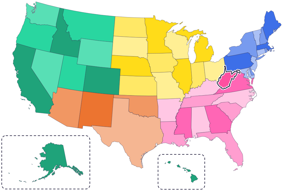
West Virginia is in the Appalachian Mountains, in the eastern part of the country. It has five neighbor states: Pennsylvania to the north, Maryland to the northeast, Virginia to the east and southeast, Kentucky to the southwest and Ohio to the northwest.
The Ohio River forms its border with Ohio, and the Potomac River runs along much of its border with Maryland. The Big Sandy River and its Tug Fork form its border with Kentucky.
Fun facts
- 1
The dome on West Virginia’s Capitol is 292 feet high, higher than the dome on the US Capitol in Washington, D.C.
- 2
The New River is among the oldest rivers on the continent, and it flows north, through deep canyons.
- 3
West Virginia’s state gem is really a fossil: coral that lived in warm, shallow seas about 350 to 325 million years ago.
- 4
The Golden Delicious apple was discovered in Clay County in 1905. It’s the state fruit.
- 5
The highest point, Spruce Knob, is 4,861 feet above sea level. The lowest, at Harpers Ferry, is 247 feet.
Places to know
New River Gorge National Park and Preserve
Near Fayetteville
The New River Gorge Bridge stands 876 feet above the river. It’s the longest steel span in the Western Hemisphere, and on Bridge Day each October, people can walk across it.

Harpers Ferry National Historical Park
Harpers Ferry, where the Shenandoah and Potomac rivers meet
Here, where two rivers meet on the ancestral home of the Tuscarora and Shawnee people, you can learn about John Brown’s raid against slavery and hike miles of trail in the Blue Ridge.

Grave Creek Mound
Moundsville
Adena people built this burial mound more than 2,000 years ago, moving more than 57,000 tons of sand and earth. A museum next door shows how they lived.
West Virginia long ago
Adena people begin building Grave Creek Mound, one of the largest Adena mounds.
John Brown leads a raid against slavery at Harpers Ferry. On October 18, US Marines capture him and some of his men.
In May, Virginia’s voters approve leaving the United States. Leaders from the western counties meet in Wheeling and set up a Virginia government loyal to the Union.
On June 20, West Virginia becomes the 35th state. Its first capital is Wheeling.
After a statewide vote, Charleston is named the permanent capital.
The New River Gorge Bridge opens. A drive that took 40 minutes now takes less than a minute.
State symbols
- State animalBlack bearsince 1973
- State birdCardinalsince 1949
- State flowerRhododendronsince 1903
- State treeSugar maplesince 1949
- State fruitGolden Delicious applesince 1995
Tricks to remember West Virginia
- Two handles. West Virginia has two panhandles: a skinny one pointing north between Ohio and Pennsylvania, and one pointing east between Maryland and Virginia.
- West of Virginia. West Virginia was the western part of Virginia until 1863, so look just northwest of Virginia.
- Think mountains. Its nickname is the Mountain State, and its motto, Montani Semper Liberi, means “Mountaineers are always free.”
- Follow the Ohio River. The river runs along the northwest side, between West Virginia and Ohio.
To practice, print a blank US map and color in West Virginia, or find it in the 50 states quiz. Then try today’s mystery state: guess it from its shape, with a clue after each miss.
Teaching all 50? Read how to teach kids the 50 states and what age kids learn the states and capitals, or follow our free 36-week homeschool geography plan.
West Virginia in Map Otter
In Map Otter, kids find West Virginia on the map, learn its capital, and collect its stamp in their passport, with Otto guiding the way. These screenshots show how it looks with a few example states.



Map Otter is coming soon to iPhone, iPad, Android phones and tablets, and Chromebooks.
Questions kids ask
What is the capital of West Virginia?
Charleston. The capital moved back and forth between Wheeling and Charleston before Charleston was named the permanent capital in 1877.
Why is it called West Virginia?
It was the western part of Virginia. During the Civil War, leaders in its western counties stayed loyal to the Union, and the western part became a new state in 1863.
Why is it called the Mountain State?
For its mountains. Its highest point, Spruce Knob, is 4,861 feet above sea level.
What is the biggest city in West Virginia?
Charleston, the capital. It isn’t the same city as Charleston, South Carolina.
Where these facts come from
- West Virginia Legislature: state symbols
- West Virginia Legislature: West Virginia facts
- National Park Service: New River Gorge National Park and Preserve
- National Park Service: New River Gorge Bridge
- National Park Service: Harpers Ferry National Historical Park
- West Virginia Department of Arts, Culture and History: Grave Creek Mound
- West Virginia Archives and History: on this day in October
- West Virginia Archives and History: ratifying the Ordinance of Secession
- West Virginia Archives and History: West Virginia statehood
- West Virginia Archives and History: the new state of West Virginia
- US Census Bureau: state area measurements
- US Census Bureau: state population estimates, 2020 to 2025
- US Census Bureau: city and town population estimates, 2020 to 2025
- US Senate Manual: ratification of the Constitution by the 13 original states
- US Senate Manual: states admitted into the Union
- US Census Bureau: census regions and divisions
- NOAA Office for Coastal Management: shoreline mileage of the United States
