
Maine facts for kids

Maine (say MAYN) is the Pine Tree State, and it has just one neighbor state. A moose is on its state seal, and its official state treat is the whoopie pie.
Quick answers
- Where is Maine?
- Maine is in the Northeast region of the United States. It touches one state: New Hampshire.
- What is the capital of Maine?
- Augusta. The biggest city is Portland.
- Does Maine touch the ocean?
- Yes. Maine has a coast on the Atlantic Ocean.
- How big is Maine?
- 35,380 square miles. It’s the 39th biggest of the 50 states.
Maine at a glance
- Capital
- Augusta
- Nickname
- The Pine Tree State
- Region
- Northeast in Map Otter. The US Census Bureau puts it in the Northeast.
- Became a state
- March 15, 1820, the 23rd state
- Biggest city
- Portland
- Size
- 35,380 square miles, the 39th biggest
- People
- About 1.4 million (2025), the 42nd most
- Neighbors
- New Hampshire
Where is Maine?
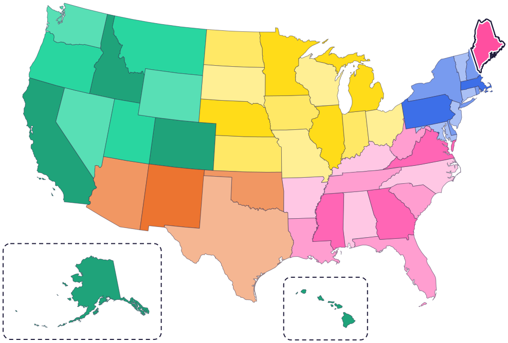
Maine is in New England, in the far northeast corner of the country. It touches just one state: New Hampshire, to the west.
Canada wraps around the rest of its land border: the province of Quebec to the northwest and New Brunswick to the northeast and east. To the south and east is the Atlantic Ocean, along a rocky coast with many islands.
Fun facts
- 1
Maine’s state seal shows a moose resting under a pine tree, with a farmer on one side and a sailor on the other. The North Star is at the top.
- 2
Maine’s state “flower” isn’t really a flower. It’s the cone and tassel of the pine tree, and the white pine is the state tree too.
- 3
The whoopie pie is Maine’s official state treat: two cakes with a creamy frosting between them.
- 4
Together, the Native nations of Maine are known as the Wabanaki, or “People of the Dawnland.”
- 5
Maine has an official state cat, the Maine coon, and an official state crustacean, the Maine lobster.
Places to know

Acadia National Park
Mount Desert Island
When Samuel de Champlain landed here in 1604, he named the island Isles des Monts Déserts, for its bare, rocky mountaintops.
Baxter State Park
Northern Maine
Home of Katahdin. Governor Percival Baxter set out to make this wilderness park for the people of Maine, and he wanted Katahdin to stay their mountain forever.

Saint Croix Island
Near Calais
In the hard winter of 1604 to 1605, a French expedition was stuck on this island. Many of the men died, and help from Passamaquoddy people kept the rest alive.
Maine long ago
Wabanaki people come here over land and in birchbark canoes. Maliseet, Mi’kmaq, Passamaquoddy and Penobscot people live throughout Maine today.
A French expedition led by Pierre Dugua spends the winter on Saint Croix Island. The Passamaquoddy, who have cared for this land for thousands of years, help the survivors.
On March 15, Maine becomes the 23rd state. Before that, it was the District of Maine, part of Massachusetts. Maine celebrates Statehood Day every March 15.
George Dorr gives 5,000 acres of land, and President Wilson creates Sieur de Monts National Monument on Mount Desert Island.
It becomes Lafayette National Park, with Dorr as its first superintendent. In 1929 it gets the name it has today: Acadia National Park.
State symbols
- State animalMoosesince 1979
- State catMaine coon catsince 1985
- State treatWhoopie piesince 2011
- State crustaceanMaine lobstersince 2015
Tricks to remember Maine
- Only one neighbor. Maine touches just one other state, New Hampshire. No other state in the lower 48 has only one neighbor state.
- Top right corner. On a map of the lower 48 states, Maine is the big state in the top right corner.
- Remember the seal. Picture a moose resting under a pine tree, with the North Star above. That’s Maine’s seal, with its state animal and its state tree.
To practice, print a blank US map and color in Maine, or find it in the 50 states quiz. Then try today’s mystery state: guess it from its shape, with a clue after each miss.
Teaching all 50? Read how to teach kids the 50 states and what age kids learn the states and capitals, or follow our free 36-week homeschool geography plan.
Maine in Map Otter
In Map Otter, kids find Maine on the map, learn its capital, and collect its stamp in their passport, with Otto guiding the way. These screenshots show how it looks with a few example states.



Map Otter is coming soon to iPhone, iPad, Android phones and tablets, and Chromebooks.
Questions kids ask
What is the capital of Maine?
Augusta. Maine’s biggest city is Portland, on the coast.
Was Maine always a state?
No. It was a district of Massachusetts until 1820, when it became its own state.
How many states does Maine touch?
Just one: New Hampshire, to the west. Maine’s other land neighbor is the country of Canada.
What is Maine’s state animal?
The moose, since 1979. A moose is on the state seal too.
Where these facts come from
- Maine Revised Statutes, Title 1, §215: state animal
- Maine Revised Statutes, Title 1, §201: state seal
- Maine Revised Statutes, Title 1, §211: state flower
- Maine Revised Statutes, Title 1, §208: state tree
- Maine Revised Statutes, Title 1, §225: state treat
- Maine Revised Statutes, Title 1, §217: state cat
- Maine Revised Statutes, Title 1, §229: state crustacean
- Maine Revised Statutes, Title 1, §116: Statehood Day
- Maine Law and Legislative Reference Library: sections of the Maine Constitution not printed
- National Park Service: the Wabanaki at Acadia
- National Park Service: colonization and settlement of Mount Desert Island
- National Park Service: the founding of Acadia
- National Park Service: Saint Croix Island International Historic Site
- Baxter State Park
- Maine Revised Statutes, Title 1, chapter 9: state symbols
- US Senate Manual: states admitted into the Union
- US Census Bureau: state area measurements
- US Census Bureau: state population estimates, 2020 to 2025
- US Census Bureau: city and town population estimates, 2020 to 2025
- US Senate Manual: ratification of the Constitution by the 13 original states
- US Census Bureau: census regions and divisions
- NOAA Office for Coastal Management: shoreline mileage of the United States
